


Silviculture & Ecophysiology
The silviculture & ecophysiology group is establishing a regionwide monitoring network to evaluate the effects of climate, soils, and management approaches planted pine carbon sequestration rates and develop standardized methods to quantify carbon, water, and nutrient storage and flux baselines, as well as responses to climate and management.
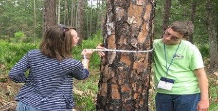
Tier I (Legacy Experiments) consists of sites chosen from an existing network of several thousand growth and yield cooperative plots which blanket the region to provide extensive, spatially-explicit information on regional variability in productivity. A wide range of growth and yield trial series are available, some of which include management treatments such as planting density, thinning, fertilization, and weed control. Most of these plots have repeated tree inventory measurements (i.e., survival, trees/acre, and tree height and diameter) and thus provide excellent information on spatial and temporal variability in tree productivity across the soil and climate factors in the region.
Click here to view a map of the Tier I (Legacy Experiment) sites.
Tier II (Active Experiments) consists of sites chosen from existing cooperative field studies and planted pine AmeriFlux installations which cover the full range of climate and soils in the region, and most of which include replicated silvicultural treatments. All of these trials have multiple historical tree inventory measurements, and some have additional carbon and nitrogen budget measurements. Tier II sites are being selected based on the strength of existing data for each trial and to maximize variation in geography, soils, climate, stand age, and treatment (focusing on nutritional, competition control, and thinning or planting density treatments). New, more intensive measurements on Tier II sites enable standardized quantification of carbon and nitrogen pools and fluxes including soil heterotrophic respiration, the key link between net primary production and net ecosystem production.
Click here to view a map of the Tier II (Active Experiment) sites.
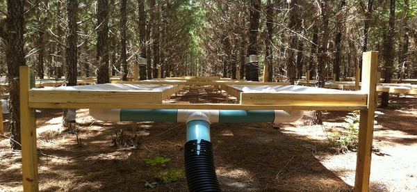
Tier III (Throughfall Exclusion and Fertilization Experiments) consist of experiments established in four key locations at the edges of the loblolly pine range which span the full temperature and precipitation range of the species. Rainfall exclusion structures have been installed to reduce precipitation by 30% which is at the extreme end of predictions for precipitation and/or soil moisture variation associated with climate change for the region. Furthermore, because most planted pine forests are nutrient limited and nutrient management is widespread, it is important to examine the interaction of rain throughfall exclusion treatment with an imposed nutritional gradient on Tier 3.
Click here to view a map of the Tier III (Throughfall Exclusion & Fertilization Experiment) sites.
At sites in McCurtain County, Oklahoma, Buckingham County, Virginia, Taliaferro County, Georgia, and Taylor County, Florida, four replications of a 2x2 factorial experiment are being installed with the following treatments:
- Control: no treatment
- Fertilizer: fertilizer additions to achieve "optimum" nutrition
- Throughfall exclusion: panels installed in understory to divert 30% of throughfall off of the plot
- Fertilizer + rain throughfall exclusion: combined fertilizer and throughfall exclusion treatments
Data being collected within the three-tiered monitoring network  includes:
- Vegetation and soil sampling (including leaf area, standing live and dead trees, understory vegetation, coarse and fine woody detritus, forest floor and soil organic matter, roots, and chemical and physical soil properties collected at various depths).
- Growth response data combined with carbon and nitrogen pool data to determine nitrogen use efficiency.
- Various ecophysiological measurements (including sap flow measurements, transpiration and whole-tree water use, wood density measurements, and soil respiration).