|
|
- Info
Photos For Rotating Banner
-
Primary Banner Image
-
Pine Integrated Network: Education, Mitigation, and Adaptation Project (PINEMAP) is a USDA National Institute of Food and Agriculture Coordinated Agricultural Project, Award # 2011-68002-30185.
Photo courtesy of Tim Martin.
-
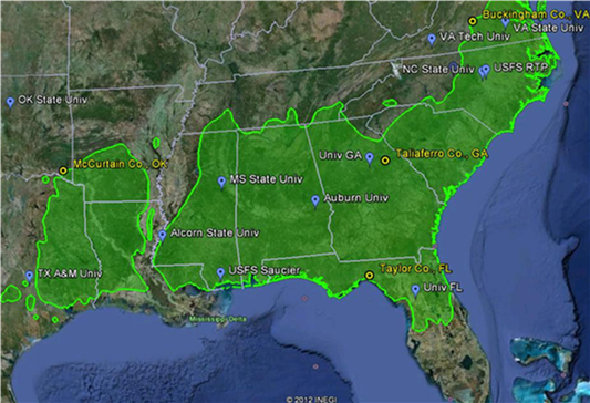
PINEMAP Map
-
The green shaded area in this map depicts the native range of loblolly pine; blue tags show collaborating institutions and yellow circles show locations of manipulative field experiments to examine the interaction of soil nutrient and water availability.
Remote sensing image courtesy Google Earth; range map courtesy USDA Forest Service.
-
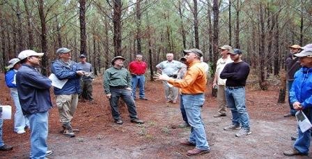
PINEMAP Team 2013 Annual Meeting
-
PINEMAP team members pose for a photo during the 2013 annual meeting field tour at the Tier III throughfall exclusion x fertilization site in Taliaferro County, GA.
-
Aerial view Tier III site, Taylor County, Florida
-
Aerial view of PINEMAP Tier III throughfall exclusion x fertilization site in Taylor County, Florida. Photo courtesy of Tim Martin.
-
Loblolly pine foliage and cone
-
Loblolly pine foliage and cone.
Photo courtesy of John Seiler.
-
Completed enclosure--VA Tier III site
-
Throughfall exclusion structures at Tier III site in Buckingham County, Virginia. Photo courtesy of Andy Laviner.
-
Florida Tier 3_Rainfall exclusion and sap flow
-
Sap flow monitors and throughfall exclusion structures at the Tier III site in Taylor County, Florida. Photo courtesy of Jessica Ireland
-
Field tour of Taliaferro County, GA Tier III site
-
PINEMAP researchers participate in a field tour of the Tier III throughfall exclusion x fertilization site in Taliaferro County, Georgia. Photo courtesy of Leslie Boby.
-
2-year-old clonal loblolly plantation
-
A 2-year-old clonal loblolly pine stand located in South Carolina at the USDA Forest Service/Mead Westvaco cross carbon research plot.
Photo courtesy of John Seiler.
-
leaf level gas exchange
-
Leaf level gas exchange being measured with a Li-Cor 6400 portable photosynthesis sytem.
Photo courtesy of John Seiler.
-
Florida Tier 3_Weather Station
-
Weather station at the Tier III throughfall exclusion x fertilization site in Taylor County, Florida. Photo courtesy of Jessica Ireland.
-
GA Tier III installation
-
Tier III throughfall exclusion and fertilization site under construction in Taliaferro County, Georgia. Photo courtesy of Leslie Boby.
-
Measuring soil CO2 efflux
-
Researchers conduct spot measurements of total soil CO2 efflux.
Photo courtesy of John Seiler.
-
Carbon sampling GA Tier III
-
Jill Qi and Aaron Joslin collect soil samples at the PINEMAP Tier III site in Taliaferro County, GA. Photo by Madison Akers.
-
VA Tier III Installation
-
Throughfall exclusion structures under construction at PINEMAP Tier III site in Buckingham County, Virginia. Photo courtesy of Andy Laviner.
-
PLT Secondary Module
-
High school students participating in the University of Florida's Science Quest summer camp measure trees and calculate the amount of carbon stored in trees as part of the Project Learning Tree/PINEMAP Secondary Module activity "Counting the Carbon." Photo courtesy of Jessica Ireland.
-
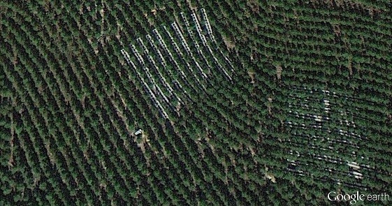
Google Earth Image_OK Tier III Site
-
Throughfall exclusion structures visible in a November 2012 Google Earth image of the Tier III site in McCurtain County, Oklahoma.
-
Tier III Washington, GA
-
Tier III throughfall exclusion x fertilization site in Taliaferro County, Georgia. Photo courtesy of Leslie Boby.
-
UG Intern Wigley and Mentor Wilson
-
Graduate student mentor Elizabeth Wilson (left) and undergraduate fellow Madison Wigley (right) record pine needle fascicle lengths in a greenhouse experiment at Texas A&M University. Photo courtesy of Ayumi Hyodo.
-
Litter trap
-
A litter trap used to estimate leaf biomass in a loblolly pine plantation.
Photo courtesy of John Seiler.
-
Fertilization VA Tier III site
-
A PINEMAP research technician spreads fertilizer at the Buckingham County, Virginia Tier III throughfall exclusion x fertilization site. Photo courtesy of Andy Laviner.
-
Truck hauling loblolly pine logs
-
A truck hauls loblolly pine logs from a harvest on the Piedmont National Wildlife Refuge near Juliette, Georgia.
Photo courtesy of Tim Martin.
-
Li-Cor 6400
-
Leaf level gas exchange being measured on clonal loblolly pine at the cross carbon site installed by the U.S. Forest Service and Meadwestvaco.
Photo Courtesy of John Seiler.
-
Florida Tier 3_Drainage Design
-
This photo shows the drainage design on the rainfall exclusion structures at the Tier III throughfall exclusion x fertilization site in Taylor County, Florida. Photo courtesy of Geoffrey Lokuta.
-
PLT Secondary Module_2
-
High school students participating in the University of Florida's Science Quest summer camp learn how carbon cycles through biological and physical systems as part of the Project Learning Tree/PINEMAP Secondary Module activity "Carbon on the Move." Photo courtesy of Jessica Ireland.
-
Heim LI-COR 6200
-
Virginia Tech M.S. student Brett Heim uses a LI-COR 6200 to measure soil respiration underneath a throughfall exclusion structure at the Virginia Tier III site.
Photo courtesy of John Seiler.
-
Tier 3 site_Taylor County, FL
-
Tier III throughfall exclusion and fertilization site in Taylor County, Florida. Photo courtesy of Jessica Ireland.
-
OK Tier III site
-
Throughfall exclusion structures at the Tier III site in McCurtain County, Oklahoma. Photo courtesy of Duncan Wilson.
-
PLT Secondary Module_3
-
High school students participating in the University of Florida's Science Quest summer camp measure trees and calculate the amount of carbon stored in trees as part of the Project Learning Tree/PINEMAP Secondary Module activity "Counting the Carbon." Photo courtesy of Martha Monroe.
-
Field Day_FL Tier III site
-
PINEMAP researchers and students participate in a field day at the Tier III throughfall exclusion x fertilization site in Taylor County, Florida. Photo courtesy of Jessica Ireland.
-
GA Tier III Througfall Exclusion
-
Throughfall exclusion structures at the Tier III site in Taliaferro County, Georgia. Photo courtesy of Madison Akers.
-
OK Tier III snow
-
Throughfall exclusion structures at the Tier III site in McCurtain County, Oklahoma holding snow from a December 2012 storm. Photo courtesy of Casey Meek.
-
Sap flow probe installation
-
University of Florida M.S. student Maxwell Wightman drills a hole to insert thermal dissipation sensor probes into a tree at the Tier III throughfall exclusion x fertilization site in Taylor County, Florida. Photo courtesy of Geoff Lokuta
-
UG weather balloon
-
Brittany Baggett (left), a 2013 undergraduate fellow from the University of West Florida, helps launch a weather balloon at the Oklahoma State University research station in Idabel, OK. Photo courtesy of Casey Meeks.
-
Climate Change Symposium for Teachers
-
Maxwell Wightman, PINEMAP graduate student, shows participants how to use a homemade clinometer to measure tree height. Photo courtesy of Jessica Ireland.
-
FL Tier III tower
-
Throughfall exclusion structures at the PINEMAP Tier III site in Taylor County, FL. Photo by Geoff Lokuta.
-
Soil respiration FL Tier III
-
PINEMAP field researchers Geoffrey Lokuta and Joshua Cucinella use a LI-COR LI-8100A instrument to measure soil respiration at the PINEMAP Tier III site in Taylor County, FL. Photo courtesy of Jessica Ireland.
|
|


