Mapping the future of southern pine management in a changing world.
-

Pine Integrated Network: Education, Mitigation, and Adaptation Project (PINEMAP) is a USDA National Institute of Food and Agriculture Coordinated Agricultural Project, Award # 2011-68002-30185. Photo courtesy of Tim Martin.

-

Graduate student mentor Elizabeth Wilson (left) and undergraduate fellow Madison Wigley (right) record pine needle fascicle lengths in a greenhouse experiment at Texas A&M University. Photo courtesy of Ayumi Hyodo.
-
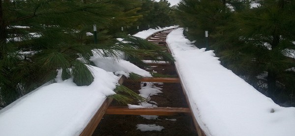
Throughfall exclusion structures at the Tier III site in McCurtain County, Oklahoma holding snow from a December 2012 storm. Photo courtesy of Casey Meek.
-

Throughfall exclusion structures at the PINEMAP Tier III site in Taylor County, FL. Photo by Geoff Lokuta.
-

PINEMAP team members pose for a photo during the 2013 annual meeting field tour at the Tier III throughfall exclusion x fertilization site in Taliaferro County, GA.
-

Sap flow monitors and throughfall exclusion structures at the Tier III site in Taylor County, Florida. Photo courtesy of Jessica Ireland
-
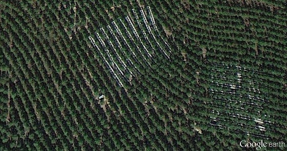
Throughfall exclusion structures visible in a November 2012 Google Earth image of the Tier III site in McCurtain County, Oklahoma.


PINEMAP Collaborators
Universities
University of Florida
|
Alcorn State University
|
University of Georgia
|
Auburn University
|
Mississippi State University
|
North Carolina A & T University
|
North Carolina State University
|
Oklahoma State University
|
Texas A & M University
|
Virginia Polytechnic Institute and State University
|
Virginia State University
University-Corporate-Governmental Research Cooperatives
Cooperative Forest Genetics Research Program |
Cooperative Tree Improvement Program |
Forest Biology Research Cooperative |
Forest Modeling Research Cooperative |
Forest Productivity Cooperative |
Plantation Management Research Cooperative |
Southern Forest Resource Assessment Consortium |
Western Gulf Forest Tree Improvement Program
Other
U.S. Forest Service | Southern Regional Extension Forestry | Southeast Climate Consortium | Additional Supporters


The Pine Integrated Network: Education, Mitigation, and Adaptation project (PINEMAP) is a Coordinated Agricultural Project funded by the USDA National Institute of Food and Agriculture, Award #2011-68002-30185.
- Log in
- Contact Us
- Subscribe
- Apr 29, 2026
-